


Modern military operations rely heavily on accurate navigation for aircraft, missiles, ships, unmanned vehicles, and ground forces. For several decades, the primary source of global positioning has been satellite-based systems such as GPS and other Global Navigation Satellite Systems (GNSS). However, these sys-tems are vulnerable to interference. In wartime, adversaries can deliberately disrupt satel-lite signals through jamming or spoofing, or satellites may become unavailable due to cyberattacks, physical destruction, or environmental effects.

As a result, armed forces increasingly invest in non-satellite navigation systems, also known as GNSS-denied navigation, to ensure reliable positioning and guidance during combat operations.
These alternative navigation methods are essential for maintaining operational capability when satellite signals are unreliable or unavailable. Many of them were developed long before satellite navigation existed and remain critical components of modern military systems.
Inertial Navigation Systems
One of the most important non-GNSS navigation methods used in defence is the Inertial Navigation System (INS). INS determines position and orientation using internal sensors rather than external signals. It typically consists of accelerometers and gyroscopes that measure linear acceleration and rotational motion.
The principle of operation is known as dead reckoning. The system starts with a known initial position and then continuously calculates the vehicle’s movement by integrating acceleration and angular velocity measurements over time. From these calculations it determines velocity, direction, and updated position.
INS has several advantages in military environments:
• It is self-contained and cannot be jammed because it does not rely on external signals.
• It works in environments where satellite reception is impossible, such as underwater, underground, or inside buildings.
• It provides very high-rate position updates, which are useful for missile guidance and aircraft control.
However, INS also has a limitation called drift error. Small measurement errors accumulate over time, gradually causing the calculated position to deviate from the true position. For this reason, modern military systems often combine INS with other non-GNSS correction methods.
Terrain Referenced Navigation and TERCOM
A widely used correction method for non-GNSS navigation is Terrain Referenced Navigation (TRN), particularly the Terrain Contour Matching (TERCOM) system used in cruise missiles. TERCOM compares the terrain beneath a vehicle with a stored digital map of the terrain.
The process typically works as follows:
1. Before a mission, the vehicle is loaded with detailed terrain elevation maps of the planned route.
2. During flight, sensors such as radar altimeters or LiDAR measure the height of the ground below the vehicle.
3. The system then compares the measured terrain profile with the stored map.
4. The navigation computer determines the best match and adjusts the vehicle’s calculated position accordingly.
This technique has been widely used in cruise missiles such as the BGM-109 Tomahawk.
Vision and image-based navigation
Another emerging GNSS-independent technique uses image-based navigation. In these systems, onboard cameras capture images of the ground or surrounding environment. Software then compares these images with stored satellite or aerial imagery to determine the vehicle’s location.
Advanced systems combine this method with inertial data to reduce drift and maintain accuracy during long missions. This technique is especially useful for unmanned aerial vehicles (UAVs) and autonomous vehicles.
CheetahNAV system
One such system is the CheetahNAV developed by Etion Create, which provides GNSS-denied navigation primarily through an Inertial Navigation System. This navigation system is built around a tactical-grade Inertial Measurement Unit (IMU), combined with advanced sensor algorithms. This allows the system to continue calculating position even when satellite navigation signals are jammed or unavailable (see Figure 2).
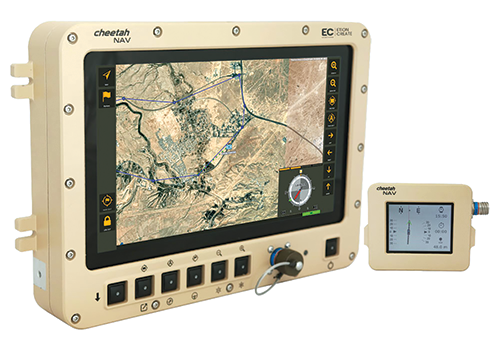
At the heart of CheetahNAV is an INS, which determines the vehicle’s position and movement using internal sensors rather than external signals. The system contains an IMU with several types of sensors, including accelerometers and gyroscopes, combined with additional aids such as a gyro-compensated compass for heading reference.
These sensors continuously measure the motion of the vehicle providing the system the ability to calculate absolute position, velocity, heading, and pitch and roll (vehicle orientation). The navigation computer performs these calculations through dead reckoning – it starts from a known position and then continuously updates that position by integrating measured values over time.
Kalman filtering
Unfortunately, raw sensor data from accelerometers and gyroscopes contains noise and small measurement errors. To correct this, CheetahNAV uses an advanced Kalman filter-based algorithm.
A Kalman filter is a mathematical algorithm used in both navigation and control systems to combine data from multiple sensors and then estimate the most likely state of the system.
In CheetahNAV, the filter typically integrates information from:
• IMU sensors (accelerometers and gyroscopes).
• Compass data.
• Optional wheel odometer inputs.
• GNSS signals – when available.
The filter then continuously predicts the vehicle’s next position based on inertial data, compares that prediction with other available measurements, and finally corrects the estimate to minimise error.
This process allows the system to maintain accurate navigation even when GNSS data is not available. When satellite signals are jammed, the system switches to pure inertial navigation. The IMU tracks vehicle motion, and the navigation computer performs dead reckoning to determine position.
In this mode, CheetahNAV achieves a horizontal position error of roughly 0,2% of the distance travelled.
This very small horizontal position error is largely due to the improvements to modern MEMS-based inertial navigational systems over the past 15 years. Systems such as CheetahNAV are far more accurate than earlier generations because of these advances in sensor manufacturing, calibration techniques, processing power, and sensor-fusion algorithms, making it viable for tactical military navigation.
Advances in MEMS sensor manufacturing
MEMS (Micro-Electro-Mechanical Systems) are extremely small mechanical sensors fabricated using semiconductor manufacturing processes similar to those used in microchips. Modern MEMS gyroscopes and accelerometers measure motion by detecting microscopic mechanical movements inside the sensor structure.
A MEMS accelerometer contains a tiny, suspended proof mass attached to micro-springs. When the device accelerates, the mass shifts slightly. This displacement changes the capacitance between electrodes, which can be measured electronically.
From Newton’s Second Law of Motion (F = m.a), the sensor is able to determine acceleration from the measured displacement and the known mass.
A MEMS gyroscope measures rotation using the Coriolis effect. A vibrating mass inside the sensor experiences a secondary motion when the device rotates.
In essence, a microscopic structure within the MEMS chip is driven to vibrate at a known frequency. This vibration is usually maintained electrostatically. If the device begins to rotate, the vibrating mass experiences a Coriolis effect that pushes it perpendicular to the vibration direction.
The MEMS structure contains capacitive sensing electrodes. When the vibrating mass shifts slightly (usually in the nanometre range), the capacitance between the two electrodes changes. The incorporated electronics then measures this small change in capacitance very precisely to determine the displacement.
Besides advancements to the MEMS accelerometer and gyroscope structure, there has been a dramatic improvement in sensor noise, a vital component to obtaining signals that can be used accurately and precisely.
Early EMS sensors suffered from large bias instability and random noise. These errors caused rapid drift in inertial navigation calculations. Modern sensors use several techniques to reduce noise:
• Closed-loop control electronics to stabilise vibration amplitude.
• Vacuum packaging to reduce damping effects.
• Temperature compensation using embedded temperature sensors.
• Precision analogue-to-digital converters.
As a result, the bias stability of tactical-grade MEMS gyroscopes has improved by roughly an order of magnitude compared with devices from fifteen years ago.
Conclusion
The increasing importance of non-GNSS navigation is largely driven by electronic warfare. Modern militaries actively develop capabilities to jam or spoof satellite signals in conflict zones. If navigation systems rely exclusively on GNSS, these attacks could disable missiles, drones, and aircraft guidance systems. By combining technologies such as INS with the latest advancements in MEMS technology, military platforms can achieve resilient navigation.
In future warfare, GNSS-denied navigation will become even more important as autonomous systems, long-range missiles, and unmanned vehicles operate in highly contested environments. Developing robust non-satellite navigation technologies therefore remains a critical priority for modern defence systems.
| Tel: | +27 12 678 9740 |
| Email: | sales@etioncreate.co.za |
| www: | www.etioncreate.co.za |
| Articles: | More information and articles about Etion Create |






© Technews Publishing (Pty) Ltd | All Rights Reserved
 printer friendly version